Home Overview Facts Duty Free Health Passports / Visas Embassy Money Public Holidays Partners Accommodation Going Out Business Top Things To Do Top Things To See Communications Getting There Getting Around Climate Map Travel Advice
Iguala
 The historic city of Iguala de la Independencia is located 102 km (63 miles) from state capital Chilpancingo in the Mexican state of Guerrero. It stands on Federal Highway 95. Iguala is the municipal seat of the municipality of the same name, located in the north-central part of the state. The city had a 2005 census population of 110,390 and the municipality 128,444. The area of the municipality is 567.1 km2 (218.96 sq mi). The city is the third-largest community in the state, after Acapulco and Chilpancingo.
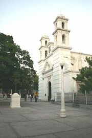
Among Iguala's main attractions are: the San Francisco Church, built in the 19th century and its surrounded by Tamarindo trees, and for that Iguala is also called "la Ciudad Tamarindera" (Tamarindo city) and the Lagoon of Tuxpan, characterized for its singular beauty. Iguala's local artisans manufacture gold and silver jewelry. General Vicente Guerrero was the first military leader to swear allegiance to the Mexican flag in Acatempan on March 12, 1821. The Plan de Iguala (published on February 24, 1821) ended the war of independence and was represented by a flag, called the flag of the three guarantees, which was made by Jose Magdaleno Ocampo. Thus the city of Iguala is called the birthplace of the modern Mexican flag. Each year a flag fair is held in Iguala. This fair is one of the most important festivities to the people of Iguala. It is celebrated with a float parade, cockfights, and handicraft exhibitions in late February.